
By Isiah Christie
It’s been a turbulent spring for New Jersey, USA, ecologically, with weather patterns nobody could predict with any certainty. Between a late rainy season, random outbursts of uncharacteristically cold and hot days, and constant weekend storms known to devastate resident off-work plans, not many are happy with the erraticism of the state’s climate – and such frustrations are only about to get worse.
The reason for this is an incoming heat wave that officially marks the beginning of summer for the state, with Sunday, June 22nd to Wednesday, June 25th hosting what is expected to be the hottest days of the year for Jersey. Temperatures are already peaking around 90° as of Saturday, June 21st, but that is only the beginning of the fiery stretch. Sunday will see a spike to a day-high 97° despite expected cloudiness, and that trend will continue into Monday with 98°. Even the absolute nightly lows – in which Jersey tends to hit moderate temperatures – will still hover around 80°, a number past weeks couldn’t even reach at their hottest.
This particular heat wave is also categorized as a “heat dome” – a phenomenon that occurs when heat is trapped over an area due to high pressure and sinks towards the surface. As the air sinks, it forms into a dome that caps the atmosphere and makes it difficult for the hot air to disperse. It is also very unlikely that rain can penetrate these conditions, which contributes to the extended periods of dryness.
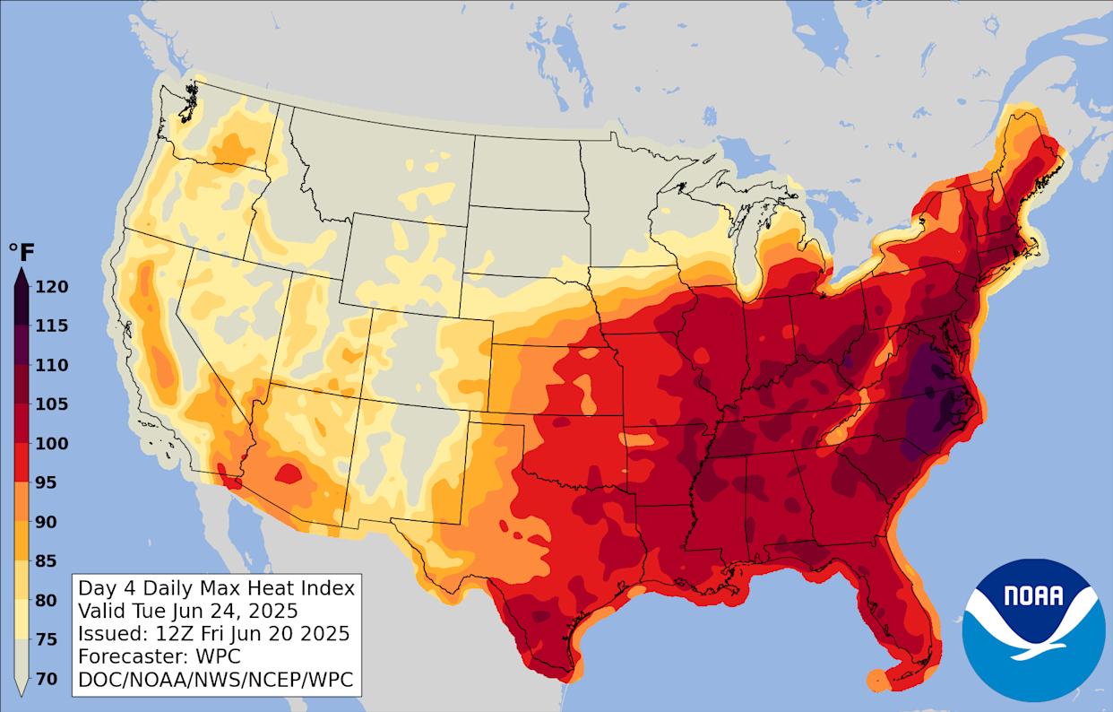
Tuesday and Wednesday are the biggest days for concern, with highs exceeding 100° and a mostly sunny forecast. Wednesday is expected to have potential scattered or isolated thunderstorms, although they are not predicted to cool down the day’s egregious heat. New Jersey’s heat index, sourced from the Weather Prediction Center, also claims that it will feel closer to 110°. This has caused counties to issue an “extreme heat watch” warning, meaning residents are encouraged to consistently hydrate themselves, avoid leaving children or pets in unattended vehicles, and contact 211 in case of missing air conditioning in their homes.
It is also recommended that those prone to heat-based illnesses are very careful with their exposure to the temperature, which will be unforgivingly dry. The warning was issued to the counties of Burlington, Camden, Gloucester, Hunterdon, Mercer, Middlesex, Morris, Somerset, Sussex, and Warren.
Bergen, Essex, Hudson, Passaic and Union counties were also issued with a “hazardous weather outlook”, meaning residents of those areas are recommended to follow similar guidelines on managing the heat. This also includes keeping a close watch on youth and seniors susceptible to extreme conditions, limiting outside activity to early mornings and evenings, and wearing lightweight clothing. If actions have not been taken to secure the protection of one and their loved ones regarding this event, it is recommended that concerned citizens take action immediately. Weather conditions are expected to regress to the norm around Wednesday night, and should be completely normalized by Thursday morning.